

GPS resilience in the face of cyber crime
Orolia Maritime's Sean McCrystal outlines the latest technology that is making superyacht navigation safer…
Superyacht captains are typically security conscious due to the value of their vessel and the conspicuous wealth and VIP nature of their owners and passengers. But now that crew and passenger connectivity increase pressure to maintain onshore communications, security threats have moved beyond passerelle monitoring and remote access lock down traditionally associated with opportunistic thieves and kidnappers, and more towards potential cyber-crime.
Cyber-attacks come in many guises, acting as a route for fraudsters to forge invoices or alter cargo manifests to hide illicit goods. As the threats become more sophisticated, poor cyber security could compromise a vessel’s safety through interference with navigation accuracy. This might sound like the plot of a Bond movie rather than a realistic concern for superyacht owners or captains, but unfortunately that is not the case.
The clearest example of the threat to the superyacht community was the White Rose of Drachs experiment, in which a team secretly piloted an 65m motoryacht sailing 30 miles offshore in the Mediterranean Sea by overriding the ship's GPS signals, without any alarms being raised by the crew. The team began broadcasting false GPS data at low power. By gradually increasing the strength of their signals they were able to overpower the aerials and spoof the on-board navigation systems.
The experiment, which took place with the ship-owner's permission, is part of continuing research by the Austin University team into GPS (GNSS) spoofing. The experiment later demonstrated how the same spoofing technique could be used from 1km away against a GPS-guided drone. Understanding navigation resilience, therefore, is fundamental in countering the reality of cyber security, and this piece highlights the vulnerabilities and the steps that can be taken to counter them.
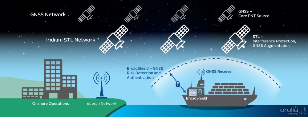
Positioning and timing have been the foundation blocks for navigation since man first took to the oceans. Since the development of the Global Navigation Satellite System (GNSS) in the late 70s, Position, Navigation and Timing (PNT) based on satellite input has been vital to many critical systems on board superyachts, allowing GNSS receivers to determine location to high precision using time signals transmitted from space. The maritime industry relies on trustworthy PNT in transport infrastructure, navigation, communications, search and rescue applications, fishing operations, regulation and increasingly in recreational boating.
However, GNSS has well-known vulnerabilities and limitations that require protection and mitigation, such as disruption by unintentional interference, is unencrypted in civilian use and is susceptible to attack. Intentional interference can be the denial of access to satellite signals or jamming, so your vessel cannot determine its exact location, or Spoofing; also known as advanced jamming; which is the creation of additional signals that provide misleading PNT information, so the vessel’s position is no longer accurate.
The operational impact of resilience is the ability to detect vulnerabilities in GNSS, such as spoofing or jamming incidents, issue alerts to the vessel and provide alternative sources of navigation and positioning.
Resilient PNT is the convergence of positioning, navigation and timing technology with non-traditional and emerging technology to improve the reliability, performance and safety of mission-critical applications – where even the smallest discrepancy in data accuracy can impact the safety, security and economic viability of vessels at sea. Resilience offers vessels’ position information it can trust, by protecting, authenticating and offering alternatives to existing PNT sources such as GNSS. The operational impact of resilience is the ability to detect vulnerabilities in GNSS, such as spoofing or jamming incidents, issue alerts to the vessel and provide alternative sources of navigation and positioning.
Alternative navigation signals such as Satellite Time and Location (STL), offer an encrypted signal 1000x stronger than GNSS that resists spoofing. STL is available worldwide, operating on the Iridium satellites. Though not as accurate as GNSS, it provides 30 to 50m accuracy which can serve as a check to the GNSS indicated position. When combined with an Inertial Navigation System (INS), it can provide valuable range and Doppler updates to the inertial measurements, reducing drift and maintaining a proper navigation solution even during extended periods of GNSS denial.
eLoran, where available, provides a diverse alternative signal for Navigation Protection Devices. It is at the other end of the spectrum from GNSS: low frequency instead of microwave; high-power pulse instead of low-power spread spectrum; and terrestrial instead of space-based. The jammer required to block GNSS is very different from one designed to block eLoran, adding resiliency to navigation.
A Navigation Protection Device (NPD) monitors GNSS receptions, analyses the signals, compares the ship’s navigation solution against other reference systems and alerts the pilot on the bridge. The NPD is independent of the vessel’s navigation system and interfaces with the ECDIS display to give real time indication of alerts and positional discrepancies. Three detection scenarios exist that would indicate there is a problem: the NPD activates on the presence of additional signals in the GNSS band and anomalous behaviour of the signal; it determines its navigation solution does not match the ship’s GNSS guidance solution due to equipment malfunction or malicious signals; or it identifies that the navigation solution differs from the GNSS constellations and its alternatives sources, such as STL or eLoran.
STL offers an additional signal authentication tool through geo-location. Its encrypted signal means the vessel has an irrefutable PNT source, which in turn can authenticate communication or network access, as you can trust the vessel was in a certain location at a certain time and that communications to and from the vessel are genuine. This offers huge scope in cyber security, protection network access and the big data solutions that are rapidly changing the capabilities of the maritime industry.
With the rapid uptake in new and sophisticated technology, expenditure in time and money needs to be matched in less visible but nonetheless critical cyber defences in how navigation security can support communication safety. PNT is the foundation of trusted maritime navigation and with the latest technological advancements adding resilience, safer shipping can extend trust to cyber security and secure communication too.
Click here to become part of The Superyacht Group community, and join us in our mission to make this industry accessible to all, and prosperous for the long-term. We are offering access to the superyacht industry’s most comprehensive and longstanding archive of business-critical information, as well as a comprehensive, real-time superyacht fleet database, for just £10 per month, because we are One Industry with One Mission. Sign up here.